



Digital Elevation Model Market
Digital Elevation Model Market
Market Overview
Digital elevation models provide three-dimensional representations of terrain surface elevation, generated through LiDAR, photogrammetric, and satellite radar data collection methods to support applications spanning urban planning, infrastructure development, environmental monitoring, and disaster risk assessment. As geospatial data collection technology has continued advancing alongside growing government and commercial demand for precise terrain data, digital elevation models have become foundational infrastructure supporting an expanding range of planning, engineering, and environmental applications.
Demand growth through the 2026-2033 window is closely tied to sustained government and commercial infrastructure development investment requiring precise terrain data for planning and engineering applications, growing environmental monitoring and climate change adaptation programs requiring elevation data for flood and disaster risk assessment, and continued advancement in LiDAR and satellite data collection technology improving elevation model accuracy and resolution. Growing smart city and digital twin initiative investment continues to expand demand for high-resolution digital elevation data across urban environments.
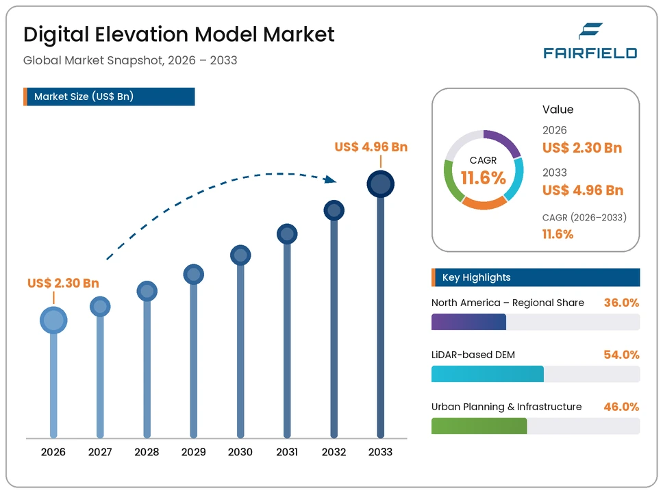
The market is valued at USD 2.30 Billion in 2026, with data providers directing investment toward improved data collection technology that enhances elevation model accuracy and reduces production costs. By 2033, the market is forecast to reach USD 4.96 Billion, reflecting rapid growth across established LiDAR-based applications alongside accelerating satellite radar-based adoption.
Key Highlights
- The global digital elevation model market is valued at USD 2.30 Billion in 2026 and is projected to reach USD 4.96 Billion by 2033, expanding at a CAGR of 11.6% across the 2026-2033 forecast period.
- LiDAR-based DEM leads the data-type segment with a 54.0% share in 2026, equivalent to USD 1.24 Billion.
- Urban Planning & Infrastructure remains the dominant application, accounting for 46.0% of global demand, or USD 1.06 Billion, in 2026.
- North America commands the largest regional share at 36.0% of the global market in 2026.
- Satellite radar-based DEM is emerging as the fastest-growing data-type category through 2033.
Market Dynamics
Key Growth Drivers
Growth in the digital elevation model market is driven primarily by sustained government and commercial infrastructure development investment, as continued urban and infrastructure planning activity requires precise terrain data supporting engineering and site assessment applications.
A second driver is growing environmental monitoring and climate change adaptation programs, as governments and organizations increasingly rely on elevation data to assess flood risk, coastal erosion, and other climate-related environmental hazards.
Key Restraints
The substantial cost of high-resolution LiDAR data collection creates budget constraints for smaller organizations and developing region applications, limiting access to the highest-accuracy elevation datasets.
Additionally, data processing complexity associated with converting raw elevation data into usable digital elevation models creates technical barriers, requiring specialized geospatial processing expertise and computing infrastructure.
Market Opportunities
The expansion of satellite radar-based DEM adoption presents a substantial opportunity, as growing satellite constellation capability continues to expand cost-effective, wide-area elevation data coverage relative to traditional aerial LiDAR collection.
A second opportunity lies in continued advancement in data processing and automation technology that reduces elevation model production time and cost. Companies that successfully advance this processing capability stand to capture growing demand as organizations increasingly require frequently updated, high-resolution terrain data.
Segmentation Analysis
By Data Type
LiDAR-based DEM leads the data-type segment, accounting for 54.0% of global market value in 2026, equivalent to USD 1.24 Billion. Its leadership reflects LiDAR technology's superior accuracy and resolution for detailed terrain mapping applications. Photogrammetry-based DEM represents a significant, established data-type category. Satellite Radar-based DEM represents the fastest-growing data-type category through 2033, driven by expanding satellite constellation coverage and cost-effective wide-area data collection.
By Application
Urban Planning & Infrastructure forms the leading application segment, representing 46.0% of global demand in 2026, or USD 1.06 Billion, reflecting sustained infrastructure development activity requiring precise terrain data. Environmental Monitoring represents the fastest-growing application category, propelled by expanding climate change adaptation and disaster risk assessment programs.
Regional Insights
North America
North America holds the largest regional share, at 36.0% of the global market in 2026, equivalent to USD 0.83 Billion. The region's leadership reflects substantial government geospatial data investment and established infrastructure planning application demand across the United States and Canada.
Asia Pacific
Asia Pacific accounts for 28.0% of the global market in 2026, valued at USD 0.64 Billion. Demand is supported by rapid urban infrastructure development and growing environmental monitoring investment across China, Japan, and India.
Europe
Europe represents 26.0% of the global market in 2026, or USD 0.60 Billion. Growth is underpinned by strong environmental monitoring and infrastructure planning application adoption across major European markets.
Latin America
Latin America contributes 6.0% of the global market in 2026, equivalent to USD 0.14 Billion. Growth is linked to expanding infrastructure development and environmental monitoring investment in Brazil and Mexico.
Middle East & Africa
Middle East & Africa holds 4.0% of the global market in 2026, valued at USD 0.09 Billion. Growth remains gradual, tied to expanding regional infrastructure development investment.
Competitive Landscape
The global digital elevation model market is moderately fragmented, with a mix of large diversified geospatial technology companies and specialized elevation data providers competing for government and commercial customer adoption. Competition centers on data accuracy and resolution capability, breadth of geographic coverage, and the strength of relationships with government and infrastructure planning agencies. Companies are increasingly differentiating through expanded satellite radar data collection capability rather than competing on aerial LiDAR services alone.
Key Market Players
- Maxar Technologies Inc.
- Airbus Defence and Space
- Esri
- Hexagon AB
- Trimble Inc.
- Fugro N.V.
- TomTom N.V.
- Planet Labs PBC
- Bluesky International Limited
- Intermap Technologies Corp.
Market Segmentation
By Data Type
- LiDAR-based DEM
- Photogrammetry-based DEM
- Satellite Radar-based DEM
- Others
By Application
- Urban Planning & Infrastructure
- Environmental Monitoring
- Others
By End User
- Government Agencies
- Commercial Enterprises
By Geography
- North America
- Europe
- Asia Pacific
- Latin America
- Middle East & Africa
- Executive Summary
- Global Digital Elevation Model Market Snapshot
- Future Projections
- Key Market Trends
- Regional Snapshot, by Value, 2026
- Analyst Recommendations
- Market Overview
- Market Definitions and Segmentations
- Market Dynamics
- Drivers
- Restraints
- Market Opportunities
- Value Chain Analysis
- COVID-19 Impact Analysis
- Porter's Five Forces Analysis
- Impact of Russia-Ukraine Conflict
- PESTLE Analysis
- Regulatory Analysis
- Price Trend Analysis
- Current Prices and Future Projections, 2025-2033
- Price Impact Factors
- Global Digital Elevation Model Market Outlook, 2020 - 2033
- Global Digital Elevation Model Market Outlook, by Data Type, Value (US$ Bn), 2020-2033
- LiDAR-based DEM
- Photogrammetry-based DEM
- Satellite Radar-based DEM
- Others
- Global Digital Elevation Model Market Outlook, by Application, Value (US$ Bn), 2020-2033
- Urban Planning & Infrastructure
- Environmental Monitoring
- Others
- Global Digital Elevation Model Market Outlook, by End User, Value (US$ Bn), 2020-2033
- Government Agencies
- Commercial Enterprises
- Global Digital Elevation Model Market Outlook, by Region, Value (US$ Bn), 2020-2033
- North America
- Europe
- Asia Pacific
- Latin America
- Middle East & Africa
- Global Digital Elevation Model Market Outlook, by Data Type, Value (US$ Bn), 2020-2033
- North America Digital Elevation Model Market Outlook, 2020 - 2033
- North America Digital Elevation Model Market Outlook, by Data Type, Value (US$ Bn), 2020-2033
- LiDAR-based DEM
- Photogrammetry-based DEM
- Satellite Radar-based DEM
- Others
- North America Digital Elevation Model Market Outlook, by Application, Value (US$ Bn), 2020-2033
- Urban Planning & Infrastructure
- Environmental Monitoring
- Others
- North America Digital Elevation Model Market Outlook, by End User, Value (US$ Bn), 2020-2033
- Government Agencies
- Commercial Enterprises
- North America Digital Elevation Model Market Outlook, by Country, Value (US$ Bn), 2020-2033
- U.S. Digital Elevation Model Market Outlook, by Data Type, 2020-2033
- U.S. Digital Elevation Model Market Outlook, by Application, 2020-2033
- U.S. Digital Elevation Model Market Outlook, by End User, 2020-2033
- Canada Digital Elevation Model Market Outlook, by Data Type, 2020-2033
- Canada Digital Elevation Model Market Outlook, by Application, 2020-2033
- Canada Digital Elevation Model Market Outlook, by End User, 2020-2033
- BPS Analysis/Market Attractiveness Analysis
- North America Digital Elevation Model Market Outlook, by Data Type, Value (US$ Bn), 2020-2033
- Europe Digital Elevation Model Market Outlook, 2020 - 2033
- Europe Digital Elevation Model Market Outlook, by Data Type, Value (US$ Bn), 2020-2033
- LiDAR-based DEM
- Photogrammetry-based DEM
- Satellite Radar-based DEM
- Others
- Europe Digital Elevation Model Market Outlook, by Application, Value (US$ Bn), 2020-2033
- Urban Planning & Infrastructure
- Environmental Monitoring
- Others
- Europe Digital Elevation Model Market Outlook, by End User, Value (US$ Bn), 2020-2033
- Government Agencies
- Commercial Enterprises
- Europe Digital Elevation Model Market Outlook, by Country, Value (US$ Bn), 2020-2033
- Germany Digital Elevation Model Market Outlook, by Data Type, 2020-2033
- Germany Digital Elevation Model Market Outlook, by Application, 2020-2033
- Germany Digital Elevation Model Market Outlook, by End User, 2020-2033
- Italy Digital Elevation Model Market Outlook, by Data Type, 2020-2033
- Italy Digital Elevation Model Market Outlook, by Application, 2020-2033
- Italy Digital Elevation Model Market Outlook, by End User, 2020-2033
- France Digital Elevation Model Market Outlook, by Data Type, 2020-2033
- France Digital Elevation Model Market Outlook, by Application, 2020-2033
- France Digital Elevation Model Market Outlook, by End User, 2020-2033
- U.K. Digital Elevation Model Market Outlook, by Data Type, 2020-2033
- U.K. Digital Elevation Model Market Outlook, by Application, 2020-2033
- U.K. Digital Elevation Model Market Outlook, by End User, 2020-2033
- Spain Digital Elevation Model Market Outlook, by Data Type, 2020-2033
- Spain Digital Elevation Model Market Outlook, by Application, 2020-2033
- Spain Digital Elevation Model Market Outlook, by End User, 2020-2033
- Russia Digital Elevation Model Market Outlook, by Data Type, 2020-2033
- Russia Digital Elevation Model Market Outlook, by Application, 2020-2033
- Russia Digital Elevation Model Market Outlook, by End User, 2020-2033
- Rest of Europe Digital Elevation Model Market Outlook, by Data Type, 2020-2033
- Rest of Europe Digital Elevation Model Market Outlook, by Application, 2020-2033
- Rest of Europe Digital Elevation Model Market Outlook, by End User, 2020-2033
- BPS Analysis/Market Attractiveness Analysis
- Europe Digital Elevation Model Market Outlook, by Data Type, Value (US$ Bn), 2020-2033
- Asia Pacific Digital Elevation Model Market Outlook, 2020 - 2033
- Asia Pacific Digital Elevation Model Market Outlook, by Data Type, Value (US$ Bn), 2020-2033
- LiDAR-based DEM
- Photogrammetry-based DEM
- Satellite Radar-based DEM
- Others
- Asia Pacific Digital Elevation Model Market Outlook, by Application, Value (US$ Bn), 2020-2033
- Urban Planning & Infrastructure
- Environmental Monitoring
- Others
- Asia Pacific Digital Elevation Model Market Outlook, by End User, Value (US$ Bn), 2020-2033
- Government Agencies
- Commercial Enterprises
- Asia Pacific Digital Elevation Model Market Outlook, by Country, Value (US$ Bn), 2020-2033
- China Digital Elevation Model Market Outlook, by Data Type, 2020-2033
- China Digital Elevation Model Market Outlook, by Application, 2020-2033
- China Digital Elevation Model Market Outlook, by End User, 2020-2033
- Japan Digital Elevation Model Market Outlook, by Data Type, 2020-2033
- Japan Digital Elevation Model Market Outlook, by Application, 2020-2033
- Japan Digital Elevation Model Market Outlook, by End User, 2020-2033
- South Korea Digital Elevation Model Market Outlook, by Data Type, 2020-2033
- South Korea Digital Elevation Model Market Outlook, by Application, 2020-2033
- South Korea Digital Elevation Model Market Outlook, by End User, 2020-2033
- India Digital Elevation Model Market Outlook, by Data Type, 2020-2033
- India Digital Elevation Model Market Outlook, by Application, 2020-2033
- India Digital Elevation Model Market Outlook, by End User, 2020-2033
- Southeast Asia Digital Elevation Model Market Outlook, by Data Type, 2020-2033
- Southeast Asia Digital Elevation Model Market Outlook, by Application, 2020-2033
- Southeast Asia Digital Elevation Model Market Outlook, by End User, 2020-2033
- Rest of SAO Digital Elevation Model Market Outlook, by Data Type, 2020-2033
- Rest of SAO Digital Elevation Model Market Outlook, by Application, 2020-2033
- Rest of SAO Digital Elevation Model Market Outlook, by End User, 2020-2033
- BPS Analysis/Market Attractiveness Analysis
- Asia Pacific Digital Elevation Model Market Outlook, by Data Type, Value (US$ Bn), 2020-2033
- Latin America Digital Elevation Model Market Outlook, 2020 - 2033
- Latin America Digital Elevation Model Market Outlook, by Data Type, Value (US$ Bn), 2020-2033
- LiDAR-based DEM
- Photogrammetry-based DEM
- Satellite Radar-based DEM
- Others
- Latin America Digital Elevation Model Market Outlook, by Application, Value (US$ Bn), 2020-2033
- Urban Planning & Infrastructure
- Environmental Monitoring
- Others
- Latin America Digital Elevation Model Market Outlook, by End User, Value (US$ Bn), 2020-2033
- Government Agencies
- Commercial Enterprises
- Latin America Digital Elevation Model Market Outlook, by Country, Value (US$ Bn), 2020-2033
- Brazil Digital Elevation Model Market Outlook, by Data Type, 2020-2033
- Brazil Digital Elevation Model Market Outlook, by Application, 2020-2033
- Brazil Digital Elevation Model Market Outlook, by End User, 2020-2033
- Mexico Digital Elevation Model Market Outlook, by Data Type, 2020-2033
- Mexico Digital Elevation Model Market Outlook, by Application, 2020-2033
- Mexico Digital Elevation Model Market Outlook, by End User, 2020-2033
- Argentina Digital Elevation Model Market Outlook, by Data Type, 2020-2033
- Argentina Digital Elevation Model Market Outlook, by Application, 2020-2033
- Argentina Digital Elevation Model Market Outlook, by End User, 2020-2033
- Rest of LATAM Digital Elevation Model Market Outlook, by Data Type, 2020-2033
- Rest of LATAM Digital Elevation Model Market Outlook, by Application, 2020-2033
- Rest of LATAM Digital Elevation Model Market Outlook, by End User, 2020-2033
- BPS Analysis/Market Attractiveness Analysis
- Latin America Digital Elevation Model Market Outlook, by Data Type, Value (US$ Bn), 2020-2033
- Middle East & Africa Digital Elevation Model Market Outlook, 2020 - 2033
- Middle East & Africa Digital Elevation Model Market Outlook, by Data Type, Value (US$ Bn), 2020-2033
- LiDAR-based DEM
- Photogrammetry-based DEM
- Satellite Radar-based DEM
- Others
- Middle East & Africa Digital Elevation Model Market Outlook, by Application, Value (US$ Bn), 2020-2033
- Urban Planning & Infrastructure
- Environmental Monitoring
- Others
- Middle East & Africa Digital Elevation Model Market Outlook, by End User, Value (US$ Bn), 2020-2033
- Government Agencies
- Commercial Enterprises
- Middle East & Africa Digital Elevation Model Market Outlook, by Country, Value (US$ Bn), 2020-2033
- GCC Digital Elevation Model Market Outlook, by Data Type, 2020-2033
- GCC Digital Elevation Model Market Outlook, by Application, 2020-2033
- GCC Digital Elevation Model Market Outlook, by End User, 2020-2033
- South Africa Digital Elevation Model Market Outlook, by Data Type, 2020-2033
- South Africa Digital Elevation Model Market Outlook, by Application, 2020-2033
- South Africa Digital Elevation Model Market Outlook, by End User, 2020-2033
- Egypt Digital Elevation Model Market Outlook, by Data Type, 2020-2033
- Egypt Digital Elevation Model Market Outlook, by Application, 2020-2033
- Egypt Digital Elevation Model Market Outlook, by End User, 2020-2033
- Nigeria Digital Elevation Model Market Outlook, by Data Type, 2020-2033
- Nigeria Digital Elevation Model Market Outlook, by Application, 2020-2033
- Nigeria Digital Elevation Model Market Outlook, by End User, 2020-2033
- Rest of Middle East Digital Elevation Model Market Outlook, by Data Type, 2020-2033
- Rest of Middle East Digital Elevation Model Market Outlook, by Application, 2020-2033
- Rest of Middle East Digital Elevation Model Market Outlook, by End User, 2020-2033
- BPS Analysis/Market Attractiveness Analysis
- Middle East & Africa Digital Elevation Model Market Outlook, by Data Type, Value (US$ Bn), 2020-2033
- Competitive Landscape
- Company Vs Segment Heatmap
- Company Market Share Analysis, 2025
- Competitive Dashboard
- Company Profiles
- Maxar Technologies Inc.
- Company Overview
- Product Portfolio
- Financial Overview
- Business Strategies and Developments
- Airbus Defence and Space
- Esri
- Hexagon AB
- Trimble Inc.
- Fugro N.V.
- TomTom N.V.
- Planet Labs PBC
- Bluesky International Limited
- Intermap Technologies Corp.
- Maxar Technologies Inc.
- Appendix
- Research Methodology
- Report Assumptions
- Acronyms and Abbreviations
By Data Type
- LiDAR-based DEM
- Photogrammetry-based DEM
- Satellite Radar-based DEM
- Others
By Application
- Urban Planning & Infrastructure
- Environmental Monitoring
- Others
By End User
- Government Agencies
- Commercial Enterprises
By Geography
- North America
- Europe
- Asia Pacific
- Latin America
- Middle East & Africa
Our Research Methodology
Considering the volatility of business today, traditional approaches to strategizing a game plan can be unfruitful if not detrimental. True ambiguity is no way to determine a forecast. A myriad of predetermined factors must be accounted for such as the degree of risk involved, the magnitude of circumstances, as well as conditions or consequences that are not known or unpredictable. To circumvent binary views that cast uncertainty, the application of market research intelligence to strategically posture, move, and enable actionable outcomes is necessary.
View Methodology
Quality Assured
Rigorous Validation Process

Confidentiality Assured
End-to-end Data Security

Custom Research Services
Tailored To Your Objectives
FAQs
The global digital elevation model market is valued at USD 2.30 Billion in 2026, reflecting growing demand for precise terrain data across planning and monitoring applications.
The market is projected to grow at a CAGR of 11.6%, reaching USD 4.96 Billion by 2033, driven by infrastructure development and environmental monitoring investment.
LiDAR-based DEM leads with a 54.0% share in 2026, reflecting its superior accuracy for detailed terrain mapping.
North America leads with a 36.0% share in 2026, reflecting substantial government geospatial data investment.
The largest opportunity lies in satellite radar-based DEM, expanding alongside growing satellite constellation coverage.
Related Reports
Tunnel Construction Market Size, Share, Insights, Competitive Landscape, and Forecast 2026 to 2033
The global tunnel construction market is valued at US$29.52 billion in 2026, reaching US$47.09 billion by 2033, growing at a 6.9% CAGR
Sports Analytics Market Size, Share, Insights, Competitive Landscape, and Forecast 2026 to 2033
The global sports analytics market is valued at US$7.06 billion in 2026, reaching US$23.15 billion by 2033, growing at an 18.5% CAGR
Distributed Acoustic Sensing Market Size, Share, Insights, Competitive Landscape, and Forecast 2026 to 2033
The global distributed acoustic sensing market is valued at US$0.565 billion in 2026, reaching US$1.173 billion by 2033, growing at an 11.0% CAGR
Secure Flash Drive Market Size, Share, Insights, Competitive Landscape, and Forecast 2026 to 2033
The global secure flash drive market is valued at US$0.8 billion in 2026, reaching US$1.1 billion by 2033, growing at a 4.7% CAGR
Optical I/O for AI Chips Market Size, Share, Insights, Competitive Landscape, and Forecast 2026 to 2033
The global optical I/O for AI chips market is valued at US$1.6 billion in 2026, reaching US$14.5 billion by 2033, growing at a 37.01% CAGR
Foldable Drones Market Size, Share, Insights, Competitive Landscape, and Forecast 2026 to 2033
The global foldable drones market is valued at US$3.76 billion in 2026 and is projected to reach US$7.57 billion by 2033, growing at a 10.5% CAGR.