



3D Laser Scanner Market
3D Laser Scanner Market Size, Share, Insights, Competitive Landscape, and Forecast 2026 to 2033
3D Laser Scanner Market Size and Trend Analysis
How Fast Is the 3D Laser Scanner Market Growing?
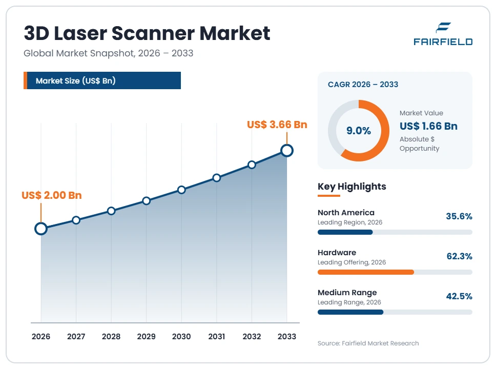
The global 3D laser scanner market size is expected to be valued at US$ 2.00 billion in 2026 and projected to reach US$ 3.66 billion by 2033, growing at a CAGR of 9.0% between 2026 and 2033.
Between 2020 and 2025, the market grew at a CAGR of about 7.6%, as construction, surveying, and manufacturing firms adopted reality capture and digital inspection after pandemic-era project delays. Three factors now drive growth: wider use of building information modeling and digital twins, stricter quality requirements in automotive and aerospace manufacturing, and faster, lighter scanners that cut field time. The market is shifting from standalone hardware toward connected scanning workflows, with cloud streaming, automated registration, and AI-based feature extraction that turn point clouds into usable models faster.
Key Report Takeaways
- By Product Type: Tripod-mounted Scanners held 36.2% share in 2026, while Handheld & Mobile Scanners are projected to expand at a 12.1% CAGR through 2033, driven by faster capture of interiors, plants, and assets.
- By Range: Medium Range held 42.5% share in 2026, while Long Range is projected to expand at a 10.6% CAGR through 2033, driven by infrastructure, mining, and large outdoor site surveys.
- By Offering: Hardware held 62.3% share in 2026, while Software is projected to expand at an 11.8% CAGR through 2033, driven by cloud registration and AI-based modeling of point clouds.
- By Application: Quality Control & Inspection held 39.4% share in 2026, while Reality Capture & BIM is projected to expand at an 11.4% CAGR through 2033, driven by digital twin and as-built documentation needs.
- By Region: North America held 35.6% share in 2026, while Asia Pacific is projected to expand at an 11.2% CAGR through 2033, driven by infrastructure building and factory automation in China and India.
Global 3D Laser Scanner Market Trends and Insights
Drivers Impact Analysis
Two drivers carry the strongest influence on 3D laser scanner demand during the forecast period.
| Driver | Impact on CAGR Forecast | Geographic Relevance | Impact Timeline |
| BIM, digital twins, and reality capture in construction | High | North America, Europe, Asia Pacific | Medium term (2–4 years) |
| Precision inspection in automotive and aerospace manufacturing | High | Europe, North America, Asia Pacific | Long term (≥4 years) |
Digital Twins and BIM Are Driving 3D Laser Scanner Adoption in Construction
Building information modeling and digital twins are the strongest drivers of 3D laser scanner adoption in construction and infrastructure. Owners and contractors need accurate as-built data to design renovations, check work, and manage assets.
The mechanism is reality capture. Terrestrial laser scanners capture millions of points per second, creating precise 3D records of buildings, plants, and sites. Software turns these point clouds into building information models and digital twins. Many governments require BIM on public projects, including the United Kingdom, several European Union members, and Singapore. In June 2026, Leica Geosystems, part of Hexagon, launched its RTC series of terrestrial laser scanners, including the RTC300, RTC500, and RTC700, with Livelink streaming of scan data to the cloud during capture. These capabilities speed coordination between field and office teams.
Precision Inspection Is Expanding 3D Laser Scanner Use in Manufacturing
Stricter precision inspection requirements are expanding 3D laser scanner use in automotive, aerospace, and industrial manufacturing. Manufacturers must verify that complex parts match digital designs within tight tolerances.
The cause is rising product complexity and quality expectations. Electric vehicles, lightweight aircraft structures, and precision castings require detailed measurement. Laser scanners mounted on portable measuring arms or used as handheld devices capture full surface geometry far faster than touch probes. Software compares scans with CAD models and highlights deviations as color maps. Companies such as Carl Zeiss, Nikon Metrology, Creaform, and Hexagon supply metrology scanners. Zeiss launched the T-SCAN Hawk 2 handheld scanner, which can scan objects several meters long. Reverse engineering of legacy parts and tooling also relies on scanning, supporting demand in maintenance and repair.
Restraints Impact Analysis
Two restraints limit how quickly 3D laser scanners reach more users.
| Restraint | Impact on CAGR Forecast | Geographic Relevance | Impact Timeline |
| High equipment cost and skills requirements | Medium | Global, strongest in emerging markets | Medium term (2–4 years) |
| Competition from photogrammetry and low-cost lidar | Medium | Global | Short term (≤2 years) |
High Equipment Costs and Skills Gaps Limit 3D Laser Scanner Adoption
High equipment costs and skills requirements limit 3D laser scanner adoption, especially among small contractors and in emerging markets. Professional terrestrial and metrology scanners can cost tens of thousands of dollars per unit.
The specific cost sources are precision optics, lasers, calibration, and software. Survey-grade scanners need accurate rotating mirrors, sensors, and inertial units, along with regular calibration. Processing software for registration, modeling, and analysis often requires annual licenses. Users need training to plan scans, manage targets, and handle large datasets. Small firms may not use scanners often enough to justify the investment, so they rent equipment or hire service providers. In Latin America, Africa, and parts of Asia Pacific, budget limits and few trained operators slow adoption beyond large engineering firms and government survey agencies.
Photogrammetry and Low-Cost Lidar Compete With 3D Laser Scanners
Competition from photogrammetry and low-cost lidar limits demand for traditional 3D laser scanners in some applications. Drones with high-resolution cameras and smartphones with lidar sensors can create 3D models at much lower cost.
The underlying cause is rapid improvement in cameras, sensors, and software. Photogrammetry software reconstructs 3D models from overlapping photos, and drone surveys can cover large sites quickly. Consumer devices with depth sensors allow quick room scans for real estate and design. New methods such as Gaussian splatting create realistic 3D scenes from video. While these tools are often less accurate than survey-grade scanners, they are good enough for many visualization and planning tasks. As a result, scanner makers must focus on accuracy, reliability, and integrated workflows to defend higher prices against cheaper capture tools.
Market Opportunities
Mobile Mapping and SLAM Scanners Open a Fast-Growing Revenue Pool
Mobile mapping and SLAM-based scanners create a fast-growing revenue pool for 3D laser scanning. These systems capture data while the operator walks, drives, or flies, greatly reducing field time compared with stationary setups.
Companies with simultaneous localization and mapping technology can capture this demand. Handheld and backpack scanners map building interiors, tunnels, and plants quickly. Vehicle-mounted systems capture roads, railways, and utilities at traffic speed. Drone-mounted lidar maps forests, mines, and power lines. Robots such as Boston Dynamics’ Spot can carry scanners for routine site documentation. Construction firms, utilities, mining companies, and transport agencies are the main customers. Mobile systems also generate recurring software and processing revenue, which supports vendor margins. Rental fleets and scanning-as-a-service providers also widen access for smaller contractors that cannot justify buying equipment outright.
Cloud Workflows and AI Feature Extraction Create a Software Revenue Pool
Cloud workflows and AI-based feature extraction create a high-margin software revenue pool in the 3D laser scanner market. Customers want point clouds turned into models, measurements, and reports quickly.
Scanner makers and software companies can capture this opportunity. Leica’s Livelink streams scan data to Hexagon GeoCloud during capture, letting teams view and register data in real time. AI tools automatically classify points as walls, pipes, or equipment, then generate models for building information modeling software. Integration with design platforms from Autodesk and Bentley Systems improves workflow continuity. Engineering firms, owners, and contractors are the main customers. Subscription pricing creates recurring revenue and deepens customer relationships beyond hardware sales. Vendors that bundle storage, collaboration, and automated deliverables can lock in long-term contracts with large owners and engineering firms managing multi-site portfolios.
Segment Analysis
- By Product Type: Tripod-mounted Scanners Lead While Handheld & Mobile Scanners Grow Fastest
Tripod-mounted Scanners held 36.2% share in 2026. Terrestrial laser scanners on tripods provide high accuracy and long range for surveying, construction, plant documentation, and heritage projects. Products such as Leica’s RTC series and FARO’s Focus line are widely used. Surveyors value their repeatable accuracy and the ability to register many scan positions into one precise model.
Handheld & Mobile Scanners are the fastest-growing product type, expanding at a 12.1% CAGR through 2033. SLAM-based handheld, backpack, and vehicle-mounted scanners capture data while moving, which shortens field time for large or complex sites. Handheld metrology scanners also allow inspection on the shop floor. Portable and fixed CMM-based and desktop scanners remain important in manufacturing. For the market, mobile growth makes scanning practical for frequent, routine documentation.
- By Range: Medium Range Leads While Long Range Grows Fastest
Medium Range held 42.5% share in 2026. Scanners with ranges of tens to about one hundred meters suit buildings, plants, and most construction sites. They balance accuracy, speed, and portability for everyday work, and they cover most interior documentation and facility management projects.
Long Range is the fastest-growing range segment, expanding at a 10.6% CAGR through 2033. Infrastructure, mining, quarries, dams, and large outdoor sites need scanners that capture distant surfaces. In October 2024, FARO introduced the Focus Premium Max, extending its scanning range to 400 meters. Long-range scanners reduce the number of setups needed. Short-range scanners serve detailed part inspection and small-object digitization. For the market, long-range growth supports infrastructure investment programs.
- By Offering: Hardware Leads While Software Grows Fastest
Hardware held 62.3% share in 2026. Scanners, accessories, and targets represent the largest share of spending, because professional instruments carry high prices and are replaced every several years. Upgrades to faster, lighter models with built-in imaging and onboard registration keep hardware revenue steady across construction and manufacturing customers.
Software is the fastest-growing offering, expanding at an 11.8% CAGR through 2033. Customers need tools to register scans, clean point clouds, create models, and compare data with designs. Cloud platforms and AI features increase software value, and many vendors now sell subscriptions. After-sales services, training, and calibration also add recurring revenue. For the market, software growth shifts value toward recurring income and makes vendors’ ecosystems more important to customers.
- By Application: Quality Control & Inspection Leads While Reality Capture & BIM Grows Fastest
Quality Control & Inspection held 39.4% share in 2026. Manufacturers in automotive, aerospace, energy, and heavy industry use laser scanners to check parts and assemblies against design models. Accurate inspection reduces scrap and rework. Automated scanning cells and robot-mounted sensors now bring inspection directly onto production lines, increasing measurement frequency.
Reality Capture & BIM is the fastest-growing application, expanding at an 11.4% CAGR through 2033. Construction firms, owners, and engineers use scans to create as-built models, track progress, and manage facilities. Digital twins of buildings, plants, and infrastructure rely on accurate scan data. Reverse engineering and virtual simulation remain important uses. For the market, reality capture growth links laser scanning to large construction and infrastructure budgets.
Geography Analysis
- Which Region Is Leading the 3D Laser Scanner Market?
North America is leading the 3D laser scanner market with a 35.6% share in 2026. The United States has large construction, infrastructure, energy, aerospace, and automotive sectors that use scanning for design and inspection. Federal infrastructure spending supports surveying and reality capture. FARO, now part of AMETEK, and Trimble are based in the region. Engineering firms widely use digital twins and building information modeling. Canada adds demand from mining, oil and gas, and infrastructure. One change shaping the region is the use of robots and drones to carry scanners for routine site documentation, reducing labor needs on large sites.
- Europe Combines Metrology and BIM Leadership in the 3D Laser Scanner Market
Europe is a major market with strengths in metrology and building information modeling. Germany hosts Carl Zeiss and strong automotive and machinery manufacturers that rely on precision inspection. Switzerland is home to Leica Geosystems, while Austria hosts Riegl, a specialist in long-range and airborne lidar. The United Kingdom requires BIM on public projects. Heritage documentation across Italy, France, and Spain uses scanning to preserve historic sites. Strict quality standards in aerospace and automotive support demand. One opportunity is digital twins for energy-efficient renovation of older buildings, supported by European Union building performance rules that require accurate data on existing structures.
- Which Region Is Growing Fastest in the 3D Laser Scanner Market?
Asia Pacific is growing fastest in the 3D laser scanner market at an 11.2% CAGR through 2033. China is investing heavily in infrastructure, smart factories, and electric vehicle production, and has growing domestic scanner makers. India is building highways, railways, metro systems, and industrial corridors that need surveying and documentation. Japan and South Korea use scanners in automotive and electronics manufacturing. Topcon in Japan is a major supplier. Cost sensitivity remains a challenge, and local brands compete aggressively on price. One opportunity is affordable mobile scanners for large infrastructure programs, especially metro, rail, and highway corridors where fast documentation shortens schedules.
- Latin America Applies 3D Laser Scanners in Mining and Infrastructure
Latin America is an emerging but promising region where large mining, infrastructure, and energy projects drive scanner demand. Chile and Peru use laser scanning and lidar to monitor mines, tailings dams, and stockpiles. Brazil and Mexico apply scanning to roads, bridges, factories, and oil and gas facilities, including offshore platforms. Key barriers include high equipment prices, currency volatility, and limited trained operators. Many firms rent scanners or hire specialist service providers instead of buying equipment. One opportunity is drone and mobile lidar for large mining and infrastructure sites, which reduces field time and improves safety in remote areas with difficult terrain.
- Middle East & Africa Uses 3D Laser Scanners for Megaprojects and Energy Assets
Middle East & Africa is a developing region where megaprojects and energy assets drive demand. Saudi Arabia and the United Arab Emirates use laser scanning to document giga-projects, airports, and smart city developments. Oil, gas, and petrochemical plants in the Gulf use scanning for maintenance and modification planning. In Africa, South Africa uses scanning in deep mining and transport infrastructure. Key barriers include high costs, limited local expertise, and reliance on imported equipment and foreign service teams. One opportunity is digital twins of Gulf energy facilities, which need accurate as-built models for safe operations, maintenance, and expansion projects.
Competitive Landscape
The 3D laser scanner market is moderately concentrated. Hexagon, through Leica Geosystems, FARO, now part of AMETEK, and Trimble lead in terrestrial and mobile scanning. Carl Zeiss, Nikon Metrology, Creaform, and Hexagon compete strongly in industrial metrology. Topcon, Riegl, Artec 3D, and NavVis serve specialized segments, while Chinese makers are expanding.
Companies compete on accuracy, range, speed, ease of use, durability, software, and price. Integrated workflows from field capture to models are a key differentiator. Large customers prefer vendors that offer scanners, registration software, cloud collaboration, training, and calibration services from one source. Smaller vendors compete through specialized products, such as Riegl in airborne and long-range lidar, NavVis in mobile mapping of indoor spaces, and Artec 3D in handheld scanners for design and healthcare. Chinese makers compete mainly on price, putting pressure on mid-range products in Asia Pacific and emerging markets.
Strategic moves show how competition is changing. FARO introduced the Focus Premium Max with a 400-meter range in October 2024. AMETEK completed its roughly US$ 920 million acquisition of FARO in July 2025, adding scale and resources. Leica Geosystems launched its RTC series with cloud streaming in June 2026, replacing the RTC360 and ScanStation P-Series. These moves show competition shifting toward platforms that combine hardware, real-time cloud workflows, and software.
Three themes shape vendor strategy. First, companies are improving speed, range, and accuracy. Second, they are adding mobile and SLAM-based scanners. Third, they are investing in cloud and AI software to deliver finished models faster.
Recent Industry Developments
- June 2026: Leica Geosystems launched the RTC300, RTC500, and RTC700 terrestrial scanners with Livelink cloud streaming – unifies its terrestrial scanner lines on one platform.
- July 2025: AMETEK completed its acquisition of FARO Technologies – strengthens resources for 3D measurement and scanning.
- October 2024: FARO introduced the Focus Premium Max with 400-meter range – targets large outdoor and infrastructure sites.
Companies Covered in the Report
- Hexagon (Leica Geosystems)
- FARO Technologies (AMETEK)
- Trimble
- Carl Zeiss
- Nikon Metrology
- Topcon
- Riegl
- Creaform
- Artec 3D
- NavVis
- Perceptron
- Teledyne Optech
3D Laser Scanner Market Report Scope
| Metric | Value |
| Study Period | 2020–2033 |
| Market Size 2026 | US$ 2.00 Billion |
| Market Size 2033 | US$ 3.66 Billion |
| CAGR 2026–2033 | 9.0% |
| Absolute Dollar Opportunity | US$ 1.66 Billion |
| Largest Market | North America |
| Fastest-Growing Market | Asia Pacific |
| Market Concentration | Medium |
| Major Players | Hexagon (Leica Geosystems), FARO Technologies (AMETEK), Trimble, Carl Zeiss, Nikon Metrology |
3D Laser Scanner Market Segmentation
Product Type
- Tripod-mounted Scanners
- Handheld & Mobile Scanners
- CMM-based Scanners
- Desktop Scanners
Range
- Short Range
- Medium Range
- Long Range
Offering
- Hardware
- Software
- Services
Application
- Quality Control & Inspection
- Reality Capture & BIM
- Reverse Engineering
- Virtual Simulation
- Others
Regions
- North America
- Europe
- Asia Pacific
- Latin America
- Middle East & Africa
- Executive Summary
- Global 3D Laser Scanner Market Snapshot
- Future Projections
- Key Report Takeaways
- Regional Snapshot
- Market Overview
- Market Definition and Report Scope
- Historical Trends 2020–2025
- Market Dynamics
- Drivers
- Digital Twins and BIM Are Driving 3D Laser Scanner Adoption in Construction
- Precision Inspection Is Expanding 3D Laser Scanner Use in Manufacturing
- Restraints
- High Equipment Costs and Skills Gaps Limit 3D Laser Scanner Adoption
- Photogrammetry and Low-Cost Lidar Compete With 3D Laser Scanners
- Market Opportunities
- Mobile Mapping and SLAM Scanners Open a Fast-Growing Revenue Pool
- Cloud Workflows and AI Feature Extraction Create a Software Revenue Pool
- Drivers
- Global 3D Laser Scanner Market Outlook, 2020–2033
- Global 3D Laser Scanner Market Outlook, by Product Type, Value (US$ Billion), 2020–2033
- Tripod-mounted Scanners
- Handheld & Mobile Scanners
- CMM-based Scanners
- Desktop Scanners
- Global 3D Laser Scanner Market Outlook, by Range, Value (US$ Billion), 2020–2033
- Short Range
- Medium Range
- Long Range
- Global 3D Laser Scanner Market Outlook, by Offering, Value (US$ Billion), 2020–2033
- Hardware
- Software
- Services
- Global 3D Laser Scanner Market Outlook, by Application, Value (US$ Billion), 2020–2033
- Quality Control & Inspection
- Reality Capture & BIM
- Reverse Engineering
- Virtual Simulation
- Others
- Global 3D Laser Scanner Market Outlook, by Region, Value (US$ Billion), 2020–2033
- North America
- Europe
- Asia Pacific
- Latin America
- Middle East & Africa
- Global 3D Laser Scanner Market Outlook, by Product Type, Value (US$ Billion), 2020–2033
- North America 3D Laser Scanner Market Outlook, 2020–2033
- North America 3D Laser Scanner Market Outlook, by Product Type, Value (US$ Billion), 2020–2033
- Tripod-mounted Scanners
- Handheld & Mobile Scanners
- CMM-based Scanners
- Desktop Scanners
- North America 3D Laser Scanner Market Outlook, by Range, Value (US$ Billion), 2020–2033
- Short Range
- Medium Range
- Long Range
- North America 3D Laser Scanner Market Outlook, by Offering, Value (US$ Billion), 2020–2033
- Hardware
- Software
- Services
- North America 3D Laser Scanner Market Outlook, by Application, Value (US$ Billion), 2020–2033
- Quality Control & Inspection
- Reality Capture & BIM
- Reverse Engineering
- Virtual Simulation
- Others
- North America 3D Laser Scanner Market Outlook, by Country, Value (US$ Billion), 2020–2033
- United States 3D Laser Scanner Market Outlook, by Product Type, 2020–2033
- United States 3D Laser Scanner Market Outlook, by Range, 2020–2033
- United States 3D Laser Scanner Market Outlook, by Offering, 2020–2033
- United States 3D Laser Scanner Market Outlook, by Application, 2020–2033
- Canada 3D Laser Scanner Market Outlook, by Product Type, 2020–2033
- Canada 3D Laser Scanner Market Outlook, by Range, 2020–2033
- Canada 3D Laser Scanner Market Outlook, by Offering, 2020–2033
- Canada 3D Laser Scanner Market Outlook, by Application, 2020–2033
- North America 3D Laser Scanner Market Outlook, by Product Type, Value (US$ Billion), 2020–2033
- Europe 3D Laser Scanner Market Outlook, 2020–2033
- Europe 3D Laser Scanner Market Outlook, by Product Type, Value (US$ Billion), 2020–2033
- Tripod-mounted Scanners
- Handheld & Mobile Scanners
- CMM-based Scanners
- Desktop Scanners
- Europe 3D Laser Scanner Market Outlook, by Range, Value (US$ Billion), 2020–2033
- Short Range
- Medium Range
- Long Range
- Europe 3D Laser Scanner Market Outlook, by Offering, Value (US$ Billion), 2020–2033
- Hardware
- Software
- Services
- Europe 3D Laser Scanner Market Outlook, by Application, Value (US$ Billion), 2020–2033
- Quality Control & Inspection
- Reality Capture & BIM
- Reverse Engineering
- Virtual Simulation
- Others
- Europe 3D Laser Scanner Market Outlook, by Country, Value (US$ Billion), 2020–2033
- Germany 3D Laser Scanner Market Outlook, by Product Type, 2020–2033
- Germany 3D Laser Scanner Market Outlook, by Range, 2020–2033
- Germany 3D Laser Scanner Market Outlook, by Offering, 2020–2033
- Germany 3D Laser Scanner Market Outlook, by Application, 2020–2033
- Switzerland 3D Laser Scanner Market Outlook, by Product Type, 2020–2033
- Switzerland 3D Laser Scanner Market Outlook, by Range, 2020–2033
- Switzerland 3D Laser Scanner Market Outlook, by Offering, 2020–2033
- Switzerland 3D Laser Scanner Market Outlook, by Application, 2020–2033
- Austria 3D Laser Scanner Market Outlook, by Product Type, 2020–2033
- Austria 3D Laser Scanner Market Outlook, by Range, 2020–2033
- Austria 3D Laser Scanner Market Outlook, by Offering, 2020–2033
- Austria 3D Laser Scanner Market Outlook, by Application, 2020–2033
- United Kingdom 3D Laser Scanner Market Outlook, by Product Type, 2020–2033
- United Kingdom 3D Laser Scanner Market Outlook, by Range, 2020–2033
- United Kingdom 3D Laser Scanner Market Outlook, by Offering, 2020–2033
- United Kingdom 3D Laser Scanner Market Outlook, by Application, 2020–2033
- Italy 3D Laser Scanner Market Outlook, by Product Type, 2020–2033
- Italy 3D Laser Scanner Market Outlook, by Range, 2020–2033
- Italy 3D Laser Scanner Market Outlook, by Offering, 2020–2033
- Italy 3D Laser Scanner Market Outlook, by Application, 2020–2033
- France 3D Laser Scanner Market Outlook, by Product Type, 2020–2033
- France 3D Laser Scanner Market Outlook, by Range, 2020–2033
- France 3D Laser Scanner Market Outlook, by Offering, 2020–2033
- France 3D Laser Scanner Market Outlook, by Application, 2020–2033
- Spain 3D Laser Scanner Market Outlook, by Product Type, 2020–2033
- Spain 3D Laser Scanner Market Outlook, by Range, 2020–2033
- Spain 3D Laser Scanner Market Outlook, by Offering, 2020–2033
- Spain 3D Laser Scanner Market Outlook, by Application, 2020–2033
- Europe 3D Laser Scanner Market Outlook, by Product Type, Value (US$ Billion), 2020–2033
- Asia Pacific 3D Laser Scanner Market Outlook, 2020–2033
- Asia Pacific 3D Laser Scanner Market Outlook, by Product Type, Value (US$ Billion), 2020–2033
- Tripod-mounted Scanners
- Handheld & Mobile Scanners
- CMM-based Scanners
- Desktop Scanners
- Asia Pacific 3D Laser Scanner Market Outlook, by Range, Value (US$ Billion), 2020–2033
- Short Range
- Medium Range
- Long Range
- Asia Pacific 3D Laser Scanner Market Outlook, by Offering, Value (US$ Billion), 2020–2033
- Hardware
- Software
- Services
- Asia Pacific 3D Laser Scanner Market Outlook, by Application, Value (US$ Billion), 2020–2033
- Quality Control & Inspection
- Reality Capture & BIM
- Reverse Engineering
- Virtual Simulation
- Others
- Asia Pacific 3D Laser Scanner Market Outlook, by Country, Value (US$ Billion), 2020–2033
- China 3D Laser Scanner Market Outlook, by Product Type, 2020–2033
- China 3D Laser Scanner Market Outlook, by Range, 2020–2033
- China 3D Laser Scanner Market Outlook, by Offering, 2020–2033
- China 3D Laser Scanner Market Outlook, by Application, 2020–2033
- India 3D Laser Scanner Market Outlook, by Product Type, 2020–2033
- India 3D Laser Scanner Market Outlook, by Range, 2020–2033
- India 3D Laser Scanner Market Outlook, by Offering, 2020–2033
- India 3D Laser Scanner Market Outlook, by Application, 2020–2033
- Japan 3D Laser Scanner Market Outlook, by Product Type, 2020–2033
- Japan 3D Laser Scanner Market Outlook, by Range, 2020–2033
- Japan 3D Laser Scanner Market Outlook, by Offering, 2020–2033
- Japan 3D Laser Scanner Market Outlook, by Application, 2020–2033
- South Korea 3D Laser Scanner Market Outlook, by Product Type, 2020–2033
- South Korea 3D Laser Scanner Market Outlook, by Range, 2020–2033
- South Korea 3D Laser Scanner Market Outlook, by Offering, 2020–2033
- South Korea 3D Laser Scanner Market Outlook, by Application, 2020–2033
- Asia Pacific 3D Laser Scanner Market Outlook, by Product Type, Value (US$ Billion), 2020–2033
- Latin America 3D Laser Scanner Market Outlook, 2020–2033
- Latin America 3D Laser Scanner Market Outlook, by Product Type, Value (US$ Billion), 2020–2033
- Tripod-mounted Scanners
- Handheld & Mobile Scanners
- CMM-based Scanners
- Desktop Scanners
- Latin America 3D Laser Scanner Market Outlook, by Range, Value (US$ Billion), 2020–2033
- Short Range
- Medium Range
- Long Range
- Latin America 3D Laser Scanner Market Outlook, by Offering, Value (US$ Billion), 2020–2033
- Hardware
- Software
- Services
- Latin America 3D Laser Scanner Market Outlook, by Application, Value (US$ Billion), 2020–2033
- Quality Control & Inspection
- Reality Capture & BIM
- Reverse Engineering
- Virtual Simulation
- Others
- Latin America 3D Laser Scanner Market Outlook, by Country, Value (US$ Billion), 2020–2033
- Chile 3D Laser Scanner Market Outlook, by Product Type, 2020–2033
- Chile 3D Laser Scanner Market Outlook, by Range, 2020–2033
- Chile 3D Laser Scanner Market Outlook, by Offering, 2020–2033
- Chile 3D Laser Scanner Market Outlook, by Application, 2020–2033
- Peru 3D Laser Scanner Market Outlook, by Product Type, 2020–2033
- Peru 3D Laser Scanner Market Outlook, by Range, 2020–2033
- Peru 3D Laser Scanner Market Outlook, by Offering, 2020–2033
- Peru 3D Laser Scanner Market Outlook, by Application, 2020–2033
- Brazil 3D Laser Scanner Market Outlook, by Product Type, 2020–2033
- Brazil 3D Laser Scanner Market Outlook, by Range, 2020–2033
- Brazil 3D Laser Scanner Market Outlook, by Offering, 2020–2033
- Brazil 3D Laser Scanner Market Outlook, by Application, 2020–2033
- Mexico 3D Laser Scanner Market Outlook, by Product Type, 2020–2033
- Mexico 3D Laser Scanner Market Outlook, by Range, 2020–2033
- Mexico 3D Laser Scanner Market Outlook, by Offering, 2020–2033
- Mexico 3D Laser Scanner Market Outlook, by Application, 2020–2033
- Latin America 3D Laser Scanner Market Outlook, by Product Type, Value (US$ Billion), 2020–2033
- Middle East & Africa 3D Laser Scanner Market Outlook, 2020–2033
- Middle East & Africa 3D Laser Scanner Market Outlook, by Product Type, Value (US$ Billion), 2020–2033
- Tripod-mounted Scanners
- Handheld & Mobile Scanners
- CMM-based Scanners
- Desktop Scanners
- Middle East & Africa 3D Laser Scanner Market Outlook, by Range, Value (US$ Billion), 2020–2033
- Short Range
- Medium Range
- Long Range
- Middle East & Africa 3D Laser Scanner Market Outlook, by Offering, Value (US$ Billion), 2020–2033
- Hardware
- Software
- Services
- Middle East & Africa 3D Laser Scanner Market Outlook, by Application, Value (US$ Billion), 2020–2033
- Quality Control & Inspection
- Reality Capture & BIM
- Reverse Engineering
- Virtual Simulation
- Others
- Middle East & Africa 3D Laser Scanner Market Outlook, by Country, Value (US$ Billion), 2020–2033
- Saudi Arabia 3D Laser Scanner Market Outlook, by Product Type, 2020–2033
- Saudi Arabia 3D Laser Scanner Market Outlook, by Range, 2020–2033
- Saudi Arabia 3D Laser Scanner Market Outlook, by Offering, 2020–2033
- Saudi Arabia 3D Laser Scanner Market Outlook, by Application, 2020–2033
- United Arab Emirates 3D Laser Scanner Market Outlook, by Product Type, 2020–2033
- United Arab Emirates 3D Laser Scanner Market Outlook, by Range, 2020–2033
- United Arab Emirates 3D Laser Scanner Market Outlook, by Offering, 2020–2033
- United Arab Emirates 3D Laser Scanner Market Outlook, by Application, 2020–2033
- South Africa 3D Laser Scanner Market Outlook, by Product Type, 2020–2033
- South Africa 3D Laser Scanner Market Outlook, by Range, 2020–2033
- South Africa 3D Laser Scanner Market Outlook, by Offering, 2020–2033
- South Africa 3D Laser Scanner Market Outlook, by Application, 2020–2033
- Middle East & Africa 3D Laser Scanner Market Outlook, by Product Type, Value (US$ Billion), 2020–2033
- Competitive Landscape
- Market Concentration and Industry Leaders
- Competitive Differentiation
- Strategic Moves and Market Direction
- Recent Industry Developments
- Company Profiles
- Hexagon (Leica Geosystems)
- FARO Technologies (AMETEK)
- Trimble
- Carl Zeiss
- Nikon Metrology
- Topcon
- Riegl
- Creaform
- Artec 3D
- NavVis
- Perceptron
- Teledyne Optech
- Appendix
- Research Methodology
- Report Assumptions
- Acronyms and Abbreviations
Product Type
- Tripod-mounted Scanners
- Handheld & Mobile Scanners
- CMM-based Scanners
- Desktop Scanners
Range
- Short Range
- Medium Range
- Long Range
Offering
- Hardware
- Software
- Services
Application
- Quality Control & Inspection
- Reality Capture & BIM
- Reverse Engineering
- Virtual Simulation
- Others
Regions
- North America
- Europe
- Asia Pacific
- Latin America
- Middle East & Africa
Our Research Methodology
Considering the volatility of business today, traditional approaches to strategizing a game plan can be unfruitful if not detrimental. True ambiguity is no way to determine a forecast. A myriad of predetermined factors must be accounted for such as the degree of risk involved, the magnitude of circumstances, as well as conditions or consequences that are not known or unpredictable. To circumvent binary views that cast uncertainty, the application of market research intelligence to strategically posture, move, and enable actionable outcomes is necessary.
View Methodology
Quality Assured
Rigorous Validation Process

Confidentiality Assured
End-to-end Data Security

Custom Research Services
Tailored To Your Objectives
FAQs
The 3D laser scanner market is valued at US$ 2.00 billion in 2026, led by tripod-mounted scanners for surveying and construction.
The market is projected to reach US$ 3.66 billion by 2033, growing at a 9.0% CAGR and adding US$ 1.66 billion.
Handheld & Mobile Scanners are growing fastest at a 12.1% CAGR through 2033, driven by faster capture of interiors and plants.
Asia Pacific is growing fastest at an 11.2% CAGR through 2033, driven by infrastructure building and factory automation in China and India.
North America holds the largest share at 35.6% in 2026, supported by strong construction, infrastructure, aerospace, and automotive inspection demand.
Related Reports
3D Machine Vision Market Size, Share, Insights, Competitive Landscape, and Forecast 2026 to 2033
The global 3D machine vision market is valued at US$9.10 billion in 2026, reaching US$22.30 billion by 2033, growing at a 13.7% CAGR
3D Concrete Printing Market Size, Share, Insights, Competitive Landscape, and Forecast 2026 to 2033
The global 3D concrete printing market is valued at US$0.30 billion in 2026, reaching US$1.20 billion by 2033, growing at a 21.9% CAGR
Elevator Maintenance Market Size, Share, Insights, Competitive Landscape, and Forecast 2026 to 2033
The global elevator maintenance market is valued at US$64.8 billion in 2026, reaching US$92.6 billion by 2033, growing at a 5.2% CAGR
Gas Insulated Power Equipment Market Size, Share, Insights, Competitive Landscape, and Forecast 2026 to 2033
The gas insulated power equipment market is valued at US$ 24.0 Bn in 2026 and is projected to reach US$ 40.5 Bn by 2033, growing at a CAGR of 7.8%
Chain Conveyors Market Size, Share, Insights, Competitive Landscape, and Forecast 2026 to 2033
The global chain conveyors market will grow from US$9.78 billion in 2026 to US$15.45 billion by 2033, at a CAGR of 6.75%, driven by industrial automation.
Reciprocating Plunger Pumps Market Size, Share, Insights, Competitive Landscape, and Forecast 2026 to 2033
The reciprocating plunger pumps market will grow from US$4.89 billion in 2026 to US$7.45 billion by 2033, at a CAGR of 6.2%.